June 28: Ridgway - Ouray - Hot Springs

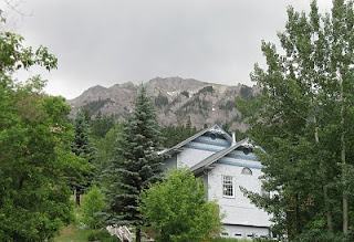
We heard there are several hot springs near Ridgway and Oaray, so we set out to check them out! The road from Montrose heading into Ridgway is amazing; looks like you're driving into the Swiss Alps.


We passed right by Orvis Hot Springs in Ridgway, because we'd heard there were hot springs in Ouray which are in a cave - sounds really neat - so we headed that way.  From Ridgway to Ouray south on the 50 Hwy - WOW!


Approaching Ouray, we were very surprised to see dark red rock all along the canyon; looked like Capitol Reef.
Ouray is in such a gorgeous setting, I kept thinking I was in the Swiss Alps. Turns out, they do call this the "Switzerland of America". An appropriate billing.  Ouray is only 10 miles from Telluride as the crow flies, but it is a 50 mile windy drive; we'll have to devote much more time to this area on another trip. We checked out the Ouray Hot Springs Pool; several folks have told us it is nice. However, it looked crowded and noisy so we passed on that one for this trip.  Check out the Ouray Hot Springs HERE


Then we checked out the Wiesbaden Hot Springs but the pool in the cave was kept at 108, which is a bit hot, so we passed on this one also. Looks like a really cool place though! Check out the cave HERE


So back to Ridgway we headed, and so glad we did! The Orvis Hot Springs just outside Ridgway were fantastic; we spent about 4 hours there and enjoyed every minute! There were seven different pools; we relaxed most of the time in The Pond, but  also enjoyed the Lobster Pot (at 108 - 110, could only handle it for a few minutes)! The landscaping, flowers, trees, flagstone walkways throughout, and incredible views up to "The Alps" were all spectacular. It was a fantastic place to relax, and both of us felt completely rejuvenated - all aches and pains are gone!  They also had a large kitchen for your use, and free coffee, tea and cocoa, showers, massage yurts, a sauna, and 6 rooms available.  Yeah, I could live here.

We loved it so much we are talking about coming back to this area (perhaps Ridgway State Park) for a couple weeks to enjoy these springs some more. Unfortunately, there were no cameras allowed (because the pools are "clothing optional") so all I have is the photo of their sign.  Their website does not do this place justice - it is incredibly beautiful. Check out Orvis Hot Springs HERE

We'll be back - could spend a whole summer here, with Telluride, Silverton, and Durango all awaiting our exploration.

June 27: West Elk Scenic Loop and Black Canyon of the Gunnison NP

We headed out to Black Canyon of the Gunnison North Rim, via Hwy 92 from the Blue Mesa Dam. Below Blue Mesa Reservoir is Morrow Point Reservoir, then Crystal Reservoir, each with their own dam. Morrow Point appears to be a river within the black canyon, below.

The story of the narrow gauge railroad in the Black Canyon is very interesting...

A view across Morrow Point reservoir with the San Juan Mountains in the background to the south; this is the same mountain range we viewed from the other side while in Lake City area.


The scenery up the 92 towards the north rim is spectacular; wildflowers everywhere. Crawford Reservoir and the West Elk mountains in the background to the east.


Below are various views of Black Canyon of the Gunnison, as seen from the North Rim. This is our nation's newest national park, which gained that status in Oct 1999 (previously a national monument). This hard dark crystalline rock is nearly 2 billion years old - some of the oldest exposed rock on earth.

The total length of the canyon is 53 miles, only 14 of which are in the national park. It's not the deepest canyon in North America, but is impressive nonetheless!  click HERE for dimensions and comparisons of this canyon to others

The river used to be many times stronger, before the dams were built upriver. It drops an average of 43 ft per mile through this canyon, and within the national park, averages 96 ft/mile and reaches 240 ft/mile in the narrows, as compared with the Colorado River which drops an average of 7.5 ft per mile through the Grand Canyon. The Gunnison drops over 4600 feet in a 48 mile stretch, farther than the Mississippi falls over its entire 1500 miles. So, it goes without saying, the black canyon is not kayak friendly. In fact, the national park website suggests that, when the river is at its strongest, "death is probable". Hmph. Think I'll skip this one.

There were signs at all the overlooks, warning to not throw rocks as there may be hikers below. I can't imagine how; the canyon walls are so incredibly sheer in most places! There are no maintained or marked trails in the inner canyon, and you can see why. 

This very first shot is the "Painted Wall", which is the tallest vertical wall in Colorado, at 2,250 ft. For advanced rock climbers only.


We headed back "home" via a loop through Crawford (great reservoir and view of the mountains), Hotchkiss (loved this little town, lots of interesting stops - restaurants, shops), and through lush green farmlands to Delta (I have a whole collection of pictures of their town murals!), and Montrose.

It was a very long day!

June 26: Crested Butte, Ohio Creek Valley, and the Gunnison River Festival

The Colorado scenery just keeps getting better...wow!  We drove a scenic loop recommended to us, from Gunnison to Crested Butte, then through the Ohio Pass into the Ohio Creek Valley, back into Gunnison. Crested Butte was an 1880's historic mining town, and they must still be mining something! Gorgeous homes everywhere and a very affluent looking town! Crested Butte also is called "the official wildflower capital" of Colorado. We were a little early for the flower show.

The scenery coming into town:
What a beautiful, clean downtown area and historic district...


From Crested Butte up the Colorado 12 to Kebler Pass, we were treated to views of the spectacular peaks of the Ruby Range, green and flowering meadows, and expansive groves of fir and aspen.


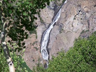
Next we headed through the Ohio Pass, seeing the giant cascading waterfall down the sides of Ohio Peak.


Views of "The Castles" and the Baldy Mountains from the Ohio CreekValley. This area is home to the world's second largest aspen stand, and must be absolutely gorgeous in fall when the aspens all change together...
The Castles, so unique and strikingly different from the surrounding mountains:


Aspen glen in the Ohio Pass; Aspens on a hillside of Colorado Sunflowers in the Ohio Creek Valley.


A view of the Anthricite Range from the valley (Ohio Peak on the right, where the cascading waterfall is).


The lush Ohio Creek Valley; many beautiful ranch homes line this valley!


Back into Gunnison, we checked out the Gunnison River Festival at Whitewater Park, where kayakers were doing tricks on one of the manmade rock structures in the "paddle playground". 

June 24 - 25: From Utah to Colorado....

No sooner did we cross into Colorado, in the area of Grand Junction, when Gary looked up and said "hey, look at that big bird" - and there was a Golden Eagle sitting on a lightpost - and he spotted it while driving! That was our welcome into Colorado. Not that Utah doesn't have Golden Eagles - we just never saw one! First stop was the visitor center which was right next to the Vietnam Vet Memorial.

First views of Colorado mountains, as we drove out of Montrose on the 50 Hwy:
Staying at Blue Mesa Recreational Ranch; the Blue Mesa Reservoir is the largest body of water in Colorado. What a contrast in scenery, to our last stop in Moab. Quite a bit cooler too! Many things to do in the area - Telluride, Black Canyon of the Gunnison NP, kayaking the Gunnison River, Crested Butte.... but the FIRST thing we did after hooking up (and before even putting out the deck!) was to jump into their brand new outdoor pool and jacuzzi.  Woo hoo!  Sure missed that. We'll be in that hot tub every night.

Today we drove the "Silver Thread Scenic Byway" through Lake City, beyond Spring Creek Pass (elev 10,901) on the Continental Divide, and back through Powdermass. We went from 72 degrees in Blue Mesa, to 46 degrees at the top. Here's a couple views of Lake San Cristobal.


From Windy Point Overlook, a view of the triangular peaks of the Big Blue Wilderness (also known as the San Juan Mountains, including Wetterhorn Peak, Matterhorn Peak, and Uncompaghre Peak). This viewpoint also overlooks the Slumgullion Earthflow which created the lake over 850 years ago:


Beyond Spring Creek Pass is North Clear Creek Falls, 100+ feet, which are believed to be the most photographed falls in Colorado:

Just beyond the waterfall, is Bristol Head, towering over Clear Creek Canyon, which reminded me of Half Dome over Yosemite Valley.
We returned to Blue Mesa via Catherdral Valley via Forest Service road 788:


Colorado Bluebells, and a valley near Powdermass: